
Since the beginning of time, human beings have stared up at the skies and wondered about their place in the world. On August 23, 1966, for the first time, we were able to see an image of what our planet looks like from the dark beyond. And it was beautiful. A new book from the Goodplanet Foundation, Earth from Space, gives an even more detailed look at the stunning planet we inhabit. The collection of satellite images allows us to see remote places for the first time as well as track the changes that we as humans are making to the planet. But most of all, it is a breathtaking look at the extraordinary place we live our ordinary lives each and every day.

Bombetoka Bay, the Betsiboka River's sludgy estuary, spans some 6 miles on Madagascar's west coast. Alluvial islands stretch out in the direction of the current, preceded and extended by sandbanks; they are partially covered by mangrove trees, seen in red in the image. In the surrounding area, the heavily cleared forest gives way to brush and cassava and rice plantations.

The Himalayas are the tallest mountain chain in the world. They include approximately fifteen thousand glaciers, which are currently affected by rising temperatures in the region—+1.8 ̊F since 1970. In the short term, their melting creates a danger of rising waters and floods downstream. But in the longer term, it indirectly threatens populations because the HImalayan glaciers supply the greatest rivers in the world: the Huang He (the Yellow River), the Yangtze, the Mekong, the Ganges, and the Indus, which irrigate areas inhabited by billions of people.

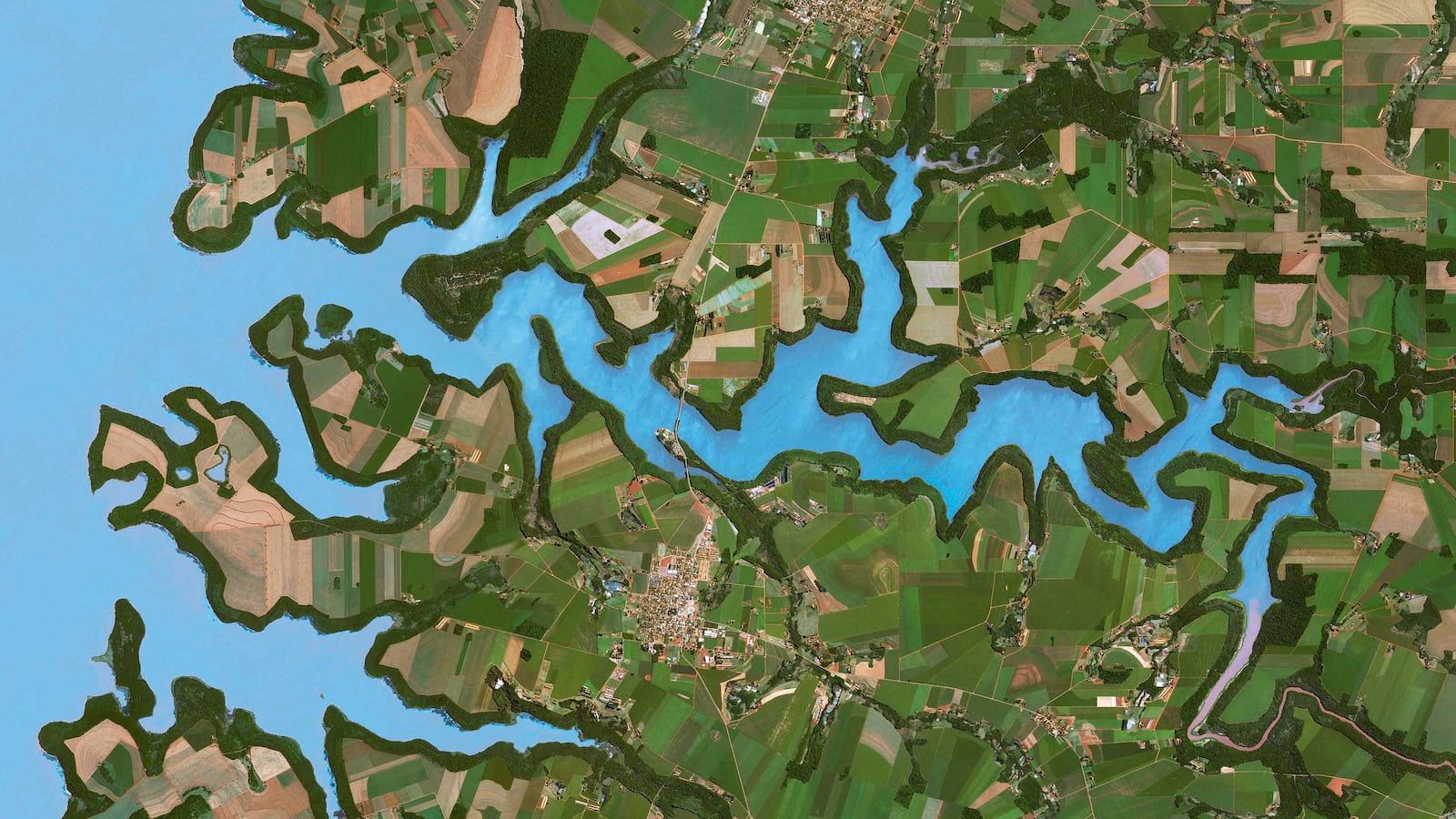
The reservoir of the Itaipu Dam, some of which can be seen here, extends oer more than 520 square miles along the border of Paraguay and Brazil. Its immediate surroundings are protected, but the rest of the area is devoted to agriculture.

The Turfan Depression in northwestern China is one of the world's lowest points. Located at about 505 feet below sea level, this windy pass at the foot of Mount Bogda saw the caravans of the Silk Road pass between its dunes and salt lakes.

The Brahmaputra River flows from a source at an altitude of about 16,400 feet in the Himalaya Kailash range of Tibet. The river valley is one of the richest sites of biodiversity in the world. Heavy floods fertilize the soil, but can also be devastating. During the monsoon, from June to October, the river is in its high-water period, while the low-water period lasts from January to March.

The grid pattern of fields and pastures borders the majestic whirlpools of the Mississippi, which boasts the largest hydrographic basin in North America. Numerous oxbow lakes underline the river's meanders south of Memphis, Tennessee, at the border of Arkansas and Mississppi.

Appropriately, the name Rub' al-Khali means "the empty quarter." It is one of the largest sand deserts on the planet, forming a rectangle roughly 600 miles long by 300 miles wide, which is located principally in Saudi Arabia, but also in Yemen, Oman, and the United Arab Emirates.

The Volga, one of Europe's largest rivers, runs 2,300 miles through Russia before flowing into the Caspian Sea. With 60 percent of its water supplied by melting snow, the Volga's flow heavily fluctuates from one season to the next, shifting from a mean of 141,000 cubic feet per second in winter to close to 900,000 cubic feet in the months of May and June.

At more than 250 miles long and 62 miles wide, the Lambert Glacier is the largest glacier in the world. Because it is 1.5 miles thick and hard to access, we resort to satellite images to study it. This image, taken with infrared sensors, shows cracks in the ice, which descend more than 1,300 feet.

The Ordos Desert is an area of steppes and desert covering more than 34,750 square miles in southern Inner Mongolia. With the exception of the Huang He (the Yellow River) valley, the region is arid and poor, cut off by steep hills in the north and crisscrossed by dunes in the south.

Running 2,734 miles, the Lena River is one of the longest rivers in the world. The Lena Delta Nature Reserve, an important refuge for many Siberian wild species, is one of the largest protected wild environments in Russia. Here, vegetation is shown in green, sand zones in pink, and water in blue-mauve. The delta's tundra, which is frozen during the region's seven months of winter, turns into a lush wet zone in the summer.

Covering a surface area of 5 million square miles, Antarctica is the biggest desert on Earth. The presence of ice—frozen water—is not antithetical to the definition of a desert; one of the major criteria for aridity is a low level of precipitation.